|
Home - The Village Today - History - Maps - Memories - Newspapers - Picture Gallery - World Wars |
|
Home - The Village Today - History - Maps - Memories - Newspapers - Picture Gallery - World Wars |
|
Stanley Stanley Parish and Area History (Page 1) by Terry Hall 2000 Present day Stanley is a Parish of some 2,400 inhabitants six miles to the North East of the Borough of Derby, and three miles to the West of the borough of Ilkeston. It is in the Parliamentary Division, and also the Rural District of South East Derbyshire. The Wapentake was the Appletree Hundred. Stanley Common, one mile distant to the North of Stanley Village, forms part of the Parish, and since the Boundary Commission Revision of 1938 the Hamlet of Smalley Common has been included in the Parish for administrative purpose. Smalley Common was included in Stanley Parish for ecclesiastical purposed - by order made on 24th March, 1965.
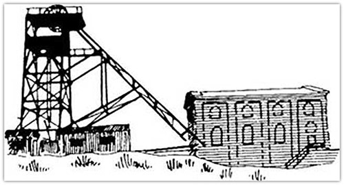
from Ilkeston to Morley and Derby and to Belper and Ripley. The soil is fertile, suitable for either arable or dairy' farming. The sub soil is clay. The chief crops are wheat, barley, oats, sugar beet, mangolds, potatoes, and turnips. The area was rich in both coal and ironstone, both minerals having been worked for centuries. Several seams of coal outcrop in the Parish, these include the Kilburn, Low Main, Piper, Black Shale, Deep Soft, and Hard Coal. The majority of the seams have been deep mined under all the Parish by the Derby Kilbum Colliery' Co. Ltd, through their Mapperley and Stanley Collieries. Extensive opencast mining has also taken place in the parish. The collieries are now closed due to the exhaustion of reserves. The Derby Kilbum Colliery closed the Stanley Footril in 1917. Stanley Colliery' Deep Mine closed in 1959, and the Stanley Colliery' Drift Mine working the Low Main and Piper Seams closed in 1961. Mapperley Colliery closed in 1965. Clay being in abundance two brickyards were in existence until the late nineteenth century, one at Stanley and one at Stanley Common. Both sites still retain the name Brickyard. In 1829, the Parish, which included Stanley Common, had 92 houses, 368 inhabitants, and 1,031 acres, with a rateable value of £1,058. In 1891 the Parish had 1,001 inhabitants, the rateable value then being £3,549. Today (1968) the rateable value is approximately £42,480.
The story' of most old villages centres around the church, which is generally the oldest existing building, and usually the only one where local records have been kept for any length of time. Stanley is one such village, but unfortunately the Parish Records only date from 1675, as all the Church Registers prior to that date were destroyed when the Clerk's house was burned down in 1754. To compile this narrative search has had to be made amongst national and surrounding parish records. In this respect the district is fortunate for one of the Canons of Dale Abbey, Thomas de Muscam, wrote the "Chronicles of Dale Abbey", now preserved in the British Museum. There is every probability there was a Saxon settlement at Stanley. The Anglo Saxon STAEN or STAN meant a stone, and LEY. LGAY. LAY or LAH meant a meadow, field or clearing in a forest. Frequently a stone was erected as a boundary mark, or as a monument to record the deeds of STANLEY PARK Although now non-existent, Stanley Park for centuries played an important part in local history. Quite a number of volumes have been written giving versions of how a baker named Cornelius of St. Mary Street, Derby, about the year 1130, after years of piety and almsgiving, had a dream or vision telling him to go to Depedale, and serve the Lord in solitude, and of how he straightaway left without notifying anyone, and came to Stanley where he heard a woman instructing a girl to take some calves to Depedale. Cornelius followed the girl and formed the Hermitage there. The The valley of Depedale was the boundary between Ockbrook and Stanley Park, and Sow brook which runs between Dale Abbey Village and the Church was the boundary. The brook is now piped. The first attempt at creating a Priory at Depedale, was as could be expected, from the previous narrative, made on the Ockbrook side of the Sow brook. After three unsuccessful attempts the Premonstratensians were invited to build a religious house of that order in Stanley Park, which had been given for that purpose by William Fitz Ralph, Lord of the Manor of Stanley in conjunction and consultation with William de Grendon his Ockbrook counterpart and relative by marriage. The new Abbey was officially known as the Abbey of Stanley Park. It was dedicated to St. Mary and the seal contained this inscription “S Ecclesiae Santa Mariae de Parco Stanlei”. The name of Depedale persisted however and eventually became abbreviated to Dale, thus Dale Abbey. Stanley Park however figures prominently in old records and its extent can he roughly surmised from the fact that the Abbey was It is well known during its flourishing period AD 1204 to AD 1538 the Abbey received many gifts of land and property throughout the area, and that Stanley Grange was part of the domain Mention is made in the Dale Abbey “Chronicles” of a field known as Ox close, and the acreage given corresponds with a field still known by that name, which almost borders Stanley Grange Farm. Alongside Oxclose are two fields known as Abbey Woods. In Abbot Stanley's days, AD 1464 to AD 1491, an entry amongst other items states "Stanley Carr, wooded and 10 acres of Meadow 16d the tenant of the field of Stanley the pasture of Alcoft 6 acres". Was Stanley Carr the land now known as Abbey Woods'? In any case the pasture of Alcroft at Stanley still retains that name. Amongst the record of gifts made to the Abbey as far as Stanley is concerned other than Stanley Manor and Stanley Park, one finds that William Laund of Stanley gave the Canons one acre of arable land in AD 1260. In AD 1331 It is also recorded "To the Parish Pryest of Stanley 20s 0d. in reward" The name mentioned varies in different works For instance in one work the recipient is named as Sir William Cooke, in another as Roger Cooke, and in still another as Robert Cooke. One fact is very evident, the name was Cooke, and according to the list of Vicars of Spondon. Robert Cooke was Vicar 1550 to 1577. The Parish Pryest of Stanley in 1538 named Cooke, could very well be the same gentleman as the Robert Cooke, vicar of Spondon, by reason that Stanley was a Chapelry held under Spondon at that time. Mention is made in the Taxation Roll of 1291 of "Spondon cum Capella" Spondon and its Chapel, which undoubtedly refers to the Chapelry at Stanley. Although Spondon had two chapelries, Stanley and Chaddesden, the building of Chaddesden Chapelry is attributed to Henry de Chaddesden, a Canon of Lichfield and Archdeacon of Leicester during the early 14th Century.
Before we enter the Parish Church of Stanley, reader, pause with me at the Church Gates, dated AD 1887, erected at the Queen Victoria celebrations, and admire the truly rural scene, typical of an old village; the charming old thatched Thatched houses lined the roadway inside the Hall grounds to a point on Morley Lane. It is interesting to note the existing wall around the Hall grounds was built from bricks and stones of the houses demolished in the early nineteenth century. Of the 92 houses in the Parish in 1829 very few remain standing, with the exception of some old farmhouses, and of course the thatched house already mentioned, but there are still a few that have escaped demolition. This has been achieved by modernising them over the years. The building now known as "The White Hart" Inn was originally a row of cottages, and when this local hostelry underwent the latest efforts in modernisation in 1957, attempts were made to retain the old world atmosphere by preserving the old beams and ceilings. During this work a section of one of the walls exposed revealed ancient half-timbered construction, this was for some reason hastily concealed, but fortunately not before the writer was able to obtain a detailed drawing.
Now let us proceed into the Churchyard noting how beautifully it is tended these days, and it is worth recording at this point the extensions that have been made. Although the burial ground had been in use for at least seven centuries, it was not until March 1899, that any extension was consecrated. The present section in use was consecrated in September 1948. Amongst the memorials one epitaph is well worth mentioning. This was to the memory of one Luke Woodward who died December 28th 1837, in the 85th year of his age. It reads: "My steady and hammer lyes reclined. Obviously a blacksmith, but where was the blacksmith's shop in Stanley? The Blacksmith's Shop was in existence in 1853, and was included in the sale of the late Sir Hugh Bateman, Bt., estate in Stanley, held at the Bell Hotel, Derby, on June 21st 1853. The position given is on a triangular portion of land on the north side of the present Station Road where recent road widening on the corner has been completed. The earliest gravestones in the Churchyard were all of a type of sandstone similar to that quarried at Stanley Hill Quarry. Almost all have now disappeared and those remaining are so affected by erosion that no lettering can be discerned. Following the sandstone the next material used appears to be gritstone, and on this the earliest date is February 12th 1733, to one Elizabeth Radford. A number of other gritstone memorials can be seen at the west end of the Churchyard to the Radford Family, who were of Stanley Flail. Also in the same area are a number of gravestones to the Potter Family also of Stanley Hall, commencing with Samuel Potter who died August 27th 1837, aged 72 years. Slate gravestones, of which there are many fine examples evidently became popular by the end of the 18th century. These include that of Luke Woodward whose epitaph has already been mentioned, and one to Luke Scattergood later mentioned on the Singers board who died March 13th 1790, aged 87 years. Other slate examples to be found at the east end of the Church are to the Draycott's family of Stanley Grange. This family acquired Stanley Grange about the middle of the seventeenth century, and were members of the Draycott family of Loscoe, near Heanor. Little is known of this family, although the Head of the House was included in the Recently the Churchyard wall has been completely rebuilt by dry-wall building experts from Harrington, Derbyshire, which incidentally involved the addition of 40 tons of stone, obtained from the demolition of St. Alkmond's Church, Derby. During this operation the remains of the old holly hedge was removed thus affording passers-bye with an open view' of the Church. STANLEY CHURCH Dedicated to Saint Andrew, was formerly a Chapelry under Spondon until the year AD 1852, when to that date the Vicars of Spondon were in charge of Stanley Parish, and appointed Curates or Chaplains. These Vicars of Spondon can be traced back to AD 1327, in which year the Rev. William de Cherdestanton was the Vicar. There was a Church at Spondon at the time of the Doomsday Survey, when it was recorded as Spondune. There was "a priest and a Church and i mill worth v shillings and iv pence. Henry de Ferrers was Lord of the Manor. This gentleman is credited with the work of the enlargement of Spondon Church, and could have supported the building or re-building of a Chapel at Stanley, or indeed, so could the Lord of the Manor of Stanley, for it is an historical fact, Stanley Manor was in existence prior to the year AD 1200.
Disclaimer - Copyright - Is this page correct? Something wrong or missing? Please let me know. Also contributions very welcome |
 Although in the Derbyshire coalfield, there lies on all sides of the Parish large stretches of fanning land through which traverse many pleasant field side pathways. Much of the area is 250 feet above sea level, the lowest point being the Bridge Inn at 236 feet. Through the Parish passes the secondary' road from Ilkeston to Derby spanning at right angles the railway line Nottingham to Derby. Through Stanley Common and Smalley Common passes the main road
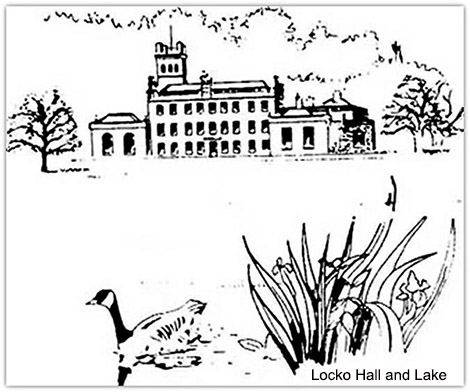 Captain P.J.B, Drury Lowe, of Locko Park, is the Lord of the Manor.
 those who had distinguished themselves in war, and as an element in making a place name. Evidence in support of an Anglo Saxon settlement came to light on the discovery made at Stanley Grange Farm in 1903 when certain Romano-British finds were made, and also when an ancient ford was unearthed during road works in 1920. No mention of a church at Stanley is made in the Doomsday Survey, which states "In Stanlie, Vlfar had ii caracutes of land hidable, land for ii ploughs. Robert the Son or William has ii villans and ii borders with plough there. There are vii acres of meadow, wood pasturable i mile in length and 1/2 in breadth. T.R.E. val xx shillings. Now x shillings the land of Robert Fite William. According to Feudal terms used at the time of the Doomsday Survey - A caracute, a carve or plough land, generally about 8 oxgangs. An oxgang was as much as an ox could till. A villan was a member of the manor. Borders were cottagers. A hide was as much as one plough would cultivate in a year.
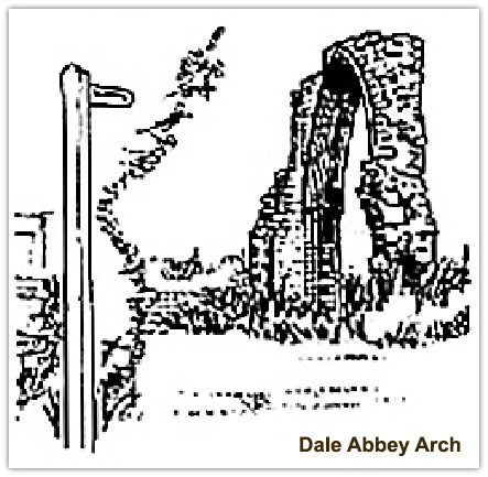 story continues of how Cornelius was found by the Lord of the Manor of Ockbrook. Ralph Fitz Geremund, when out hunting in the woods, and was so impressed by the Hermit's story and poverty that he bestowed upon him the tithe of his mill at Burgh (Borrowash). This chance meeting played an important part in the history of the locality for other members of the Fitz Geremund family, especially the Aunt of Serlo de Grendon made provision for, and invited some Canons from Calke to settle and build a church at Depedale. It is not the intention here to elaborate much further on the matter of how Dale Abbey, as it is known, came into existence, but to concentrate on the Stanley Park element.
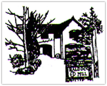 built on its southern extremity, Baldock Mill - the water mill build by a lay brother of the Canons - to the east, Stanley Grange to the north and Stanley Manor to the west. In Lyson’s "Derbyshire" there is a list of deer parks of the 14th century, which includes Kirk llallam. Mapperley. Kidsley (Smalley). Locko. Breadsall and Stanley. The abbots were on occasions called upon to defend their rights In response to a "Quo Warrante (4 Edward 3), the Abbot of Dale when asked by what right he had a park at Kirk Hallam, produced a Charter of April 1. 7 Richard 1, to Stanley Park, and stated "the Park at Kirk Hallam had been a park ever since Stanley had been a Manor, and all who have held the Manor of Stanley from the time of which no one remembers had a park at Kirk Hallam". The jurors found the Abbot and his predecessors had held it without interruption and had kept it well at all times. On another occasion. Assize Rolls 155, it appears the Abbot of Dale found it necessary to summon Ralph, the Lord of West Hallam, for making a park there. Adam the Joiner of Stanley, and Henry the Tanner of Stanley, were asked by the jurors if they had unjustly and by force dispossessed the Abbot of Dale of his common pasture in West Hallam which belongs to the freehold in Stanley. Ralph and others were fined.
 Matthew de Chaddesden and others gave land and messages in Chaddesden. Stanley and Ockbrook. Dom Richard Nottingham 18th Abbot, AD 1491 - AD 1511, granted to his predecessor Dom John Stanley, the rents of Stanley Grange (4 marks), Hilton (6 marks), and Alvaston (10 marks) to have and hold for his life. He was also to receive amongst other things "sufficient wood billets and coal for his fires". Note here the mention of coal. Amongst the items of “dettes owetng to dyvers person by the said late Monastery, before the time of the dissolution" (I538) was "To John Halom of Stanley, for eron and stele 20s 0d"
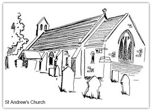 Before attempting to give details of Stanley Church, and quotations from the Church Registers, the fact that a "Parish Pryest of Stanley received 20s 0d in reward" is worth a little consideration and speculation. Reward - was there liaison between the Abbey and the Priest? This may well be the case, for it is safe to assume some of the Canons and Lay Brothers would be constantly travelling to and from the Abbey to work on their lands at Stanley, and in so doing create footpaths. Footpaths originated merely as short cuts from one point to another, and generally the focal point was the Parish Church, so it is not surprising to find a footpath through a Churchyard. Such was the case at Stanley years ago, for the late Mr. Charles Hartshorn informed the writer, he assisted his father, at an early age to dig and form a garden on that part of the land now consecrated for the Churchyard extension. When so doing they unearthed a number of stepping stones laid in a direct line with the footbridge over Stanley Brook at East Hill. Authorities on such matters gave assurance that such stones have been found on a number of occasions around churches where monasteries have existed in the vicinity, and are known as Monks Steps, by virtue of the fact that they were laid and used by monks on visits to the churches.
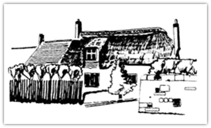 cottage, incidentally the only one in existence in the Parish, and so delightfully preserved, the stately beeches in the Hall grounds, the Village War Memorial, and the farm house with the Church School right alongside. This area was for centuries, prior to the industrial revolution and its subsequent development the hub of Stanley.
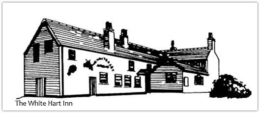 Another feature which strikes one in this area of Stanley is the complete double 'S' bend in the main road, upon which a considerable amount of expenditure has been made on widening schemes during the past forty years. Some authorities state roads were made along cattle tracks, but whatever the belief, it has often been proved there was "method in the madness", for obstructions encountered at the time of the original road making have long since disappeared. This road through Stanley is a brilliant example, for there is no apparent reason for the sharp turns. When excavations were being made along that portion of the road during the laying of a sewer in the early 1920's a discovery was made, which almost passed unnoticed at the time. At a point mid-way between "The Cedars" and The Vicarage, two stout oak baulks were encountered about two feet below the present road surface, they being approximately six feet apart at right angles with the road, the space between being filled in with boulders of various sizes.
 Authorities contacted since, considered this to be an ancient ford, and suggested searching the near vicinity for traces of an old watercourse. Sure enough, from the field adjoining the Glebe Field, an old watercourse can be traced to a point where it joined Stanley Brook. No one knows when the road or ford was made, probably by the Saxons who built the first Church of Stanley, or why and when the stream was diverted. The knowledge that it existed provides the reason for the turn in the road, i.e. to traverse the ford, and in all probability another existed at Stanley Brook where the road is carried over by a bridge alongside the Bridge Inn.
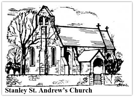 "Member of the Sixteen of Derbyshire", i.e. Sixteen of the best men in Derbyshire. The inscriptions read, "Mary the wife of John Draycott who died July 3rd 1787, aged 30 years. Also of Elizabeth his second wife who died March 29th 1797, aged 31 years. Also of John Draycott who died April 7th 1823, aged 82 years. Also William Draycott his son who died July 8th 1812, aged 24 years. Also of Thomas Draycott his son who died June 20th 1815, aged 65 years". Members of the Canner family, another family with Stanley Grange associations, and also benefactors to the Church and parish are buried in a group to the south of the Church door. The earliest tombstone to this family reads "In memory of William Canner who died October 14th 1856, aged 43 years.