If you have items of interest to add to these sections I would love to hear from you
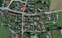
Mapperley, in Derbyshire is a remarkably compact village, housing some 300 people. It is situated off the Derby to Ilkeston route, on a u-shaped road that goes nowhere else except from High Lane to a different part of High Lane, apart from the narrow approach to Shipley Park (no through road).
It is thought that the name Mapperley derived from the number of maple trees which grew in the district.
A copy of the Royal Charter dated 1267 can be seen in the History section
 Mapperley has a primary school, a church, and a pub called The Old Black Horse which became locally famous around the turn of the century not only because it was kept by a Mr. Beer but also because he generated his own five candle power electricity on the premises even before Ilkeston had electricity.
Mapperley is an agricultural village with half a dozen working farms within the village and hamlets of Park Hall and Mapperley Brook.
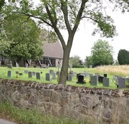
The Holy Trinity Church can be seen as you enter the village on the right at the top of the hill.
It was erected in 1851, but was badly affected by subsidencefrom the mines and closed for rebuilding in 1959. A temporary building was erected by the Coal Board until seven years later. The modern, new church was opened in April 1966, much use being made of plain glass in the western gable, and in the south windows, which command a fine view to the south looking towards Mapperley crossroads and the West Hallam Bottle Kiln. The distant bridge carried the Midland Railways mineral line, transporting the coal from Mapperley colliery to Stanton, and was built in 1875.
I hope you enjoy your tour of my Mapperley website.
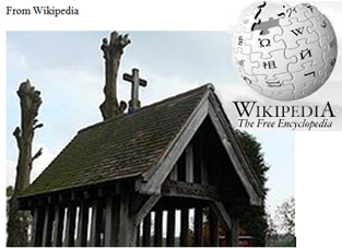
The Lychgate of the church
Mapperley is a village and civil parish in the Amber Valley district of Derbyshire,England, situated 7 miles (11 km) northeast of Derby and 2 miles (3 km) northwest of Ilkeston. [1] In the 2001 census it had a population of 253. [2]
The village is on a loop off the A609 Nottingham to Belper road. A minor road leading to Shipley was closed by Derbyshire County Council in 2007. [3]
The facilities in the village include a church, a C of E primary school and a pub called The Old Black Horse . [4]
Mapperley Colliery, which was in operation from 1871 until 1965, was formerly a major employer in the area.
In 1870-72, John Marius Wilson's Imperial Gazetteer of England and Wales described Mapperley like this:-
MAPPERLEY, a township in Kirk-Hallam parish, Derbyshire; on the Nutbrook canal, 2 miles NW of Ilkeston railway station, and 7 NE by N of Derby. It has a post office under Derby. Acres, 972. Real property, £1,556. Pop. in 1851,359; in 1861,435. Houses, 90. The increase of population arose from the extension of coal mines and iron-works in the adjacent parishes of Denby and West Hallam. There are a chapel of ease, a Wesleyan chapel, a slightly endowed Sunday school, and an infant school.
My most sincere thanks go to Fionn Taylor and Roger Wood for all their help and guidance,
without which it would not be the website you see today.
|
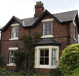
Woodlands Cottage. Many original features. |
|
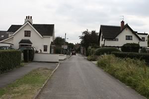
View of Main Street from Coronation Road. |
Lodge Houses
On Road From Mapperley Reservoir |
Mapperley
Extract from Derbyshire Villages Book
Mapperley is a small village which stands on the edge of Shipley Country Park. It is thought that the name derived from the number of maple trees which grew in the district. A copy of a charter dated 1267, granting the village a fair and market, can be seen in the library at Ilkeston.
Holy Trinity church can be seen as you enter the village on the right at the top of the hill. It was erected in 1851, but was badly affected by mining subsidence in 1964 causing it to close for rebuilding on more modern lines, reopening on 2nd April 1966. Lychgates were built at the entrance to the churchyard in 1922 as a memorial to the fallen of the First World War. Through these gates in springtime can be seen a carpet of crocuses and snowdrops.
A Methodist chapel was built in 1874 and opened on the 8th June 1875. People still talk of the Good Friday Teas, when Methodists from all over the district gathered and a special speaker was always invited. Sadly, the congregations became depleted and the building was sold in 1969 and is now a private house.
Mapperley colliery provided work for many of the men until it closed in 1966. A mystery that still surrounds the pit is the disappearance of Thomas Severn on 5th June 1918, never to be seen again. Much speculation has always surrounded this event.
The Old Black Horse is the remaining public house in the village. The other one, known locally as the 'Candle Stick', closed several years ago due to a methane gas leak at the property.
The only development in the village has been the building of Scandinavian houses in 1946, and in more recent years bungalows for the elderly and a few councils houses have been erected.
Mapperley was a little known village until part of Shipley Park was developed as the American Adventure Theme Park. Whilst this was welcomed by some, many preferred the Park as it was with its abundance of wildlife and quiet walks.